 Korea Bike Trail
Korean roads, construction detours and riding after dark
Last verified: 2026-07-17
How Korean bike infrastructure works
Korean law (Bicycle Use Activation Act, Article 3) defines exactly four kinds of bike road. Learn the four signs/markings and you always know who you're sharing with — and note that e-scooters (개인형이동장치) are legally allowed on all of them, so expect them near cities.
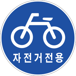
- 자전거 전용도로 (bike-only road): physically separated from cars AND sidewalks. Blue circular sign with a bicycle. The best stretches of the Cross-Country Route are this.
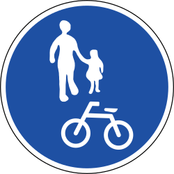
- 자전거·보행자 겸용도로 (shared bike/pedestrian path): the most common type, including most riverside parks — blue circle with pedestrians + bicycle. On split versions the surface is divided into a walking half and a riding half: keep to the bike side, it's an actual traffic rule, not a suggestion.
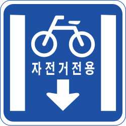
- 자전거 전용차로 (bike-only lane on the roadway): a lane carved out of the car road by lines/color, marked with a rectangular blue sign. Cars may not drive in it — but check over your shoulder anyway.
- 자전거 우선도로 (bicycle priority road): low-traffic country roads shared with cars. No separate lane — just bike-and-chevron stencils painted on the tarmac. This is what the 'quiet road' connecting sections of the route mostly are.
- Crossings: at big intersections look for the 자전거횡단도 (bicycle crossing) — a marked strip beside the pedestrian crosswalk that you may ride across. If there's only a crosswalk, dismount and walk.
- Rules that surprise visitors: helmets are legally required, and you ride on the right.

Construction zones: don't panic
On a 633 km route, some section is always being repaired. Detours are almost always signposted with a marked bypass — but in Korean.
The drill: stop, open your camera translation app (Google Lens or Papago) and point it at the sign — the detour map usually becomes obvious. If not, show a Korean rider your phone with a translated question. Cyclists on this route help each other constantly; a fellow jongju rider will often just say 'follow me'.

Riding after dark
- City sections are deceptive: the Han River parks in Seoul are lit late into the night and full of riders at 10pm.
- Rural sections are NOT lit at all. Once you leave the metropolitan parks there are long stretches with no streetlights, no buildings and sometimes no phone signal. After sunset you're riding by your own lights next to a river.
- Plan stages to finish before dusk (check sunset times — winter days are short). If you're caught out: front and rear lights on, slow down, and take the next town's motel rather than pushing on.
- Carry real lights from day one, not just reflectors — tunnels on the Saejae and Nakdong sections are dark even at noon.

If something goes wrong
- 1330 — Korea Travel Hotline: 24/7, real humans, English/Japanese/Chinese and more. Lost, confused, need anything explained? This number is your safety net for the whole trip.
- 119 — fire & ambulance (English interpreters available). 112 — police.
- Save all three before you start riding. Odds are you'll never dial any of them — that's rather the point of touring Korea.